Tuesday, January 21, 2014

COMPUTER PROGRAMS FOR DESIGN
AND MODELLING IN MINING


Miladinović Milena1, Čebašek Vladimir2, Gojković Nebojša3
FACULTY OF MINING AND GEOLOGY, BELGRADE

1. DESIGN AND METHODS FOR MODELLING IN MINING

Traditional methods for designing and modeling of open pits and underground mines, are based on manual calculations of mining parameters and manual graphic interpretation of maps, contour surface mine, landfill, dump sites. The basis of this method is a long time for data processing and design of optimal solutions, which
significantly complicates the work.
IT enables faster, better and more creative work. IT applications in mining, allowed development of new methods for open pit designing and underground mines, which is significantly different from traditional methods. This methods was called the modern methods of design and modeling. The basic assumption for its application is that the adequate database of geological and mining data, as well as the model of the deposit must be formed. Modern methods for designing and modeling are based on the integration of IT with mining activities. In some countries, modern design and modeling methods have been used for thirty years, while in the South East and East Europe optimal pits designing is based on traditional methods. The main differences between traditional and modern methods of design are given in Table 1.

2. TYPES AND CHARACTERISTICS OF MINING COMPUTER PROGRAMS

The new IT are based on the latest achievements in the development of computer equipment, software, communications and satellite navigation technology ,robotics, artificial intelligence, measurement and control techniques, fuzzy logic and systems analysis. The essence of IT applications in the mining industry is reflected in linking the functions of planning, designing, monitoring, analysis, discussion and feedback control of activity through increased production, productivity, reliability, operational safety and operability. This concept of the work activity leads to utilization of information-management systems, multi-stage hierarchical logic, with the built in artificial intelligence, high supervision and control efficiency and developing a new generation of "intelligent" mining machines – robots (Vujić, 2010). 
Mining engineers have the opportunity to follow events in the production process from the command center and redirect orders and instructions for the execution of technological operations such as drilling, blasting, loading, transportation, mineral processing, waste disposal, etc.. The benefits of introducing IT into the mining are numerous (Vujić et al. 2008). Computer programs for defining and optimizing the open pit mine contour, landfill and production planning, are the basis for process control in the open pit mines design. There are currently many professional software packages, which include economic evaluation of open pit mine, the geology of the ore body, transport communications and other technological processes. Great number of other programs for general purpose are used in addition to specialized programs for surface mining.
Computer programs for design and modelling in mining 111 There is almost no surface mine where engineers do not use any of the computer programs to assist in the implementation of specific project solutions. Number of software packages manufacturers and experts for mining, is constantly growing (Savić, 2003). Modern computer programs use different methods as the basis for the development of applications, some of which are commonly applied methods Lerchsa-Grossman (LG), Floating Cone Method and dynamic programming. LG method has the lead over other methods of design. 
Computer programs that are used in mining, according to the purpose, can be divided into the following groups:
- general-purpose software packages: mining computer programs for modeling and design of mining deposits by the means of surface and in underground mining,
- specialized software packages for optimization of surface and/or underground mining exploitation and analysis of the metallic and non-metallic minerals exploitation and
- specific application software packages, designed for the analysis of specific problems related to the design of mines or the design of exploitation technology, for example: mining cost analysis, analysis of some technical problems in surface exploitation (for example: slope stability analysis), design of the system operation (drilling and blasting, truck transportation, loading and transport) and others.

3. MINING COMPUTER PROGRAM - RRP

Today in the mining industry many computer programs are used that are tailored to the specific needs of mining activity. The database is set on site www.infomine.com, where the professional RRP are classified........................................... please download at this URL address

If you need about the mining software and the tutorial, please contact 081343990492, klick this crackingguru@gmail.com (if use Gmail) or crackingguru@gmail.com (if use yahoo mail)

Design of Surface Mine Haulage Roads - A Manual

By Walter W. Kaufman and James C. Ault
Information Circular 8758

This Bureau of Mines manual for design of surface mine haulage roads covers such aspects of haulage road
design as road alignment (both vertical and horizontal), construction materials, cross slope, and drainage provisions. Traffic control and design of proper lane widths to promote safe vehicle movement are included, as are suggested criteria for road and vehicle maintenance and for runaway vehicle safety provisions. The aim of this publication is to provide those involved with surface mine haulage road design with a complete manual of recommended practices that, if implemented, will promote safer, more efficient haulage routes.

During the past 30 years, surface mine haulage equipment has developed from trucks capable of moving 20 tons of material to vehicles that transport as much as 350 tons. Unfortunately, the design of roads this equipment must traverse has not advanced at the same rate. In many areas, road-building technology appropriate to vehicles of three decades past is still being practiced today. As a result, numerous unnecessary haulage road accidents have occurred every year. A number of these mishaps can be attributed to operator error. However, far too many are caused by road conditions that are beyond the vehicle's ability to negotiate safely. With this history of haulage related problems in mind, the Bureau of Mines undertook a project to produce a design manual that would ultimately guide surface mine road planners toward safer, more efficient haulage systems. Such a manual did not exist prior to the conclusion of this project. This manual was produced under a contract let by the Bureau of Mines to Skelly and Loy Engineers and Consultants. Information relating to the content of the manual was gathered through contacts with mining companies and equipment manufacturers across the country. Review of mining practices in some foreign countries also provided input. Literature sources relevant to good road design methods were reviewed and listed where appropriate in the text. It is the purpose of this document to identify the performance limitations of modern haulage equipment and to examine the impact of haulage road design on vehicular controllability. Based on these evaluations, haulage road design criteria that will promote continuity and safety throughout the haulage cycle were established. Time allocated for this project prohibited a detailed investigation of mechanical design for every type of haulag road user. However, safe road design criteria should be sufficiently comprehensive to allow application to all machine types.
This complication required that design criteria be based on the one type of surface mining equipment that exhibits the lowest safety potential. Research of engineering data for all major types of surface mine machinery revealed that large off the road haulage trucks had the smallest margin of safety due to their great size and weight, characteristic use, and control components. Thus, designing haulage roads to accommodate these vehicles leaves a wide margin of safety for all other surface mining equipment.
Extensive engineering data for all makes and models of large off-the-road haulage vehicles was solicited from
manufacturers. Information was tabulated to identify specifications for width, height, weight, tire track, wheel base, type of braking system, steering ability, retarded performance, speed and range on grade, and numerous other factors for each truck model. Various models were then grouped into four weight range categories, and minimum, mean, and average specifications were identified for each weight category.
Design guidelines for each weight category, including velocity stopping distance curves, vertical curve controls, haulage way widths, curve widening, and spacing of runaway devices, are presented in this report.
The haulage way designer may utilize the Contents section of this report as a checklist to assure that all elementsof design have been considered in planning the haulage road.

Resourse, please download here
If you need about the mining software and the tutorial, please contact 089520684028 klick this crackingguru@gmail.com (if use Gmail) or crackingguru@gmail.com (if use yahoo mail)

Feasibility stages of a mining project


To help you understand how a mining project, in which you might wish to invest, unfolds, here is an explanation of the various stages, from the discovery of mineral occurrences to mining operations. This shows all the work a mining company has to perform to assess the feasibility of its project.

The first objective to be met after a mineral occurrence is discovered is to obtain a wider range of samples through drilling. The goal is to estimate the quantity and quality of mineralization, i.e. the mineral resource.
Once drilling has revealed the presence of a mineral resource, the next step is to determine whether the deposit can actually be mined.

Preliminary economic assessment and feasibility studies

The mining company will conduct a preliminary economic assessment, a pre-feasibility study or a feasibility study for analyzing and evaluating the economic, technical and geological factors that will determine whether the mining project can go forward.
The results of the preliminary economic assessment will tell investors whether a mining project has the potential to be viable. At this stage, the mineralization, regardless of its quantity and quality, is always considered to be a mineral resource.
The pre-feasibility and feasibility studies are more detailed. Their results will show with more certainty whether the mining project is viable. At this point, the mineral resource, or a portion thereof, becomes a mineral reserve.

Is the project profitable?

The company must evaluate the economic profitability of the project, including whether the price of the ore on world markets will justify the investment. Uncertainty about the future price of ore could make it more difficult to obtain funding for the project. In addition, the company must take the project's environmental and social aspects into account. Is the project being accepted by the nearby communities? How far away is the nearest road?
The mining company must clearly evaluate the technical feasibility of the project. What infrastructure will be needed for extracting and concentrating the ore? Is the deposit easily accessible? Have the technologies been proven?
Throughout the assessment process, the company's officers and experts must determine whether the project justifies the large sums of money that will be needed to carry out subsequent phases of work. At each stage, the officers may put the project on hold until optimal conditions materialize (such as increased demand for the ore), or even abandon it altogether.

Mining operations

Once it has determined that the project would be profitable, the company must obtain the funding required for the development, infrastructure and mining of the deposit. Such work can take a long time and cost a lot of money. For example, it often takes 12 to 36 months for such work to be completed, and more than $500,000,000 in capital may be required to do so.
The success of a mining project depends to a large extent on the quality, integrity and competence of the mining company's officers, but luck also plays a role. For example, an unexpected drop in the price of ore could compromise the mining operations, despite the sums of money already invested.

"Most exploration projects will not generate any revenue, even after large sums of money are invested in them. This is one of the inherent risks of this industry."

Before you invest, get informed.

Here are some questions to help you start your research:
  • What are the stages involved in carrying the project to a successful conclusion?
  • How much time and money will it take to complete these stages? How will these costs be funded?
  • Do the promoters have experience and expertise in the mining industry? Have they previously carried out a mining development project successfully?
  • Are the estimates (quality of the mineral reserves or resources, production volume, costs, timeframes) presented in detail in a technical report prepared by an independent, qualified person?
  • What terms and conditions must be met in order for the company to keep its rights in the project? Are they difficult to meet?
  • What risks might impede the execution of the project?
  • Have other mining companies attempted to develop this deposit in the past, and abandoned it? Why did they abandon it? What will this company do differently?
  • How much money has been raised for, and spent on, this project?
  • Is the project located in a politically stable country?

If you need about the mining software and the tutorial, please contact 7FB8F37D (pin BB) klick this crackingguru@gmail.com (if use Gmail) or crackingguru@gmail.com (if use yahoo mail)

Friday, May 24, 2013

Methods of Mining


According to the Kentucky Department of Mines and Minerals, 131.8 million tons of coal was mined in Kentucky in 2000; 62 percent (81 million tons) was from underground mines and 38 percent (50 million tons) was from surface mines. There were 264 active underground mines and 240 active surface mines in Kentucky in 2000.

Underground Mining
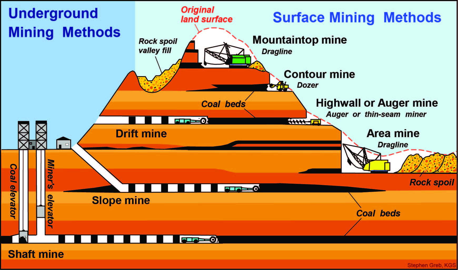
Underground modes of access include drift, slope, and shaft mining, and actual mining methods include longwall and room and pillar mining. Drift mines enter horizontally into the side of a hill and mine the coal within the hill. Slope mines usually begin in a valley bottom, and a tunnel slopes down to the coal to be mined. Shaft mines are the deepest mines; a vertical shaft with an elevator is made from the surface down to the coal. In western Kentucky, one shaft mine reaches 1,200 feet below the surface.
In room and pillar mining, the most common type of underground coal mining, coal seams are mined by a "continuous miner" that cuts a network of "rooms" into the seam. As the rooms are cut, the continuous miner simultaneously loads the coal onto a shuttle or ram car where it will eventually be placed on a conveyor belt that will move it to the surface. "Pillars" composed of coal are left behind to support the roof of the mine. Each "room" alternates with a "pillar" of greater width for support. Using this mining method normally results in a reduction in recovery of as much as 60 percent because of coal being left in the ground as pillars. As mining continues, roof bolts are placed in the ceiling to avoid ceiling collapse. Under special circumstances, pillars may sometimes be removed or "pulled" toward the end of mining in a process called "retreat mining." Removing support during retreat mining can lead to roof falls, so the pillars are removed in the opposite direction from which the mine advanced: hence the term "retreat mining."
Longwall mining is another type of underground mining. Mechanized shearers are used to cut and remove the coal at the face of the mine. After the coal is removed, it drops onto a chain conveyor, which moves it to a second conveyor that will ultimately take the coal to the surface. Temporary hydraulic-powered roof supports hold up the roof as the extraction process proceeds. This method of mining has proven to be more efficient than room and pillar mining, with a recovery rate of nearly 75 percent, but the equipment is more expensive than conventional room and pillar equipment, and cannot be used in all geological circumstances. As mining continues, roof bolts are placed in the ceiling to avoid ceiling collapse. In longwall mining, only the main tunnels are bolted. Most of the longwall panel is allowed to collapse behind the shields (which hold the roof as coal is excavated).

Surface Mining


Surface-mining methods include area, contour, mountaintop removal, and auger mining. Area mines are surface mines that remove shallow coal over a broad area where the land is fairly flat. Huge dragline shovels commonly remove rocks overlying the coal (called overburden). After the coal has been removed, the rock is placed back into the pit. Contour mines are surface mines that mine coal in steep, hilly, or mountainous terrain. A wedge of overburden is removed along the coal outcrop on the side of a hill, forming a bench at the level of the coal. After the coal is removed, the overburden is placed back on the bench to return the hill to its natural slope. Mountaintop removal mines are special area mines used where several thick coal seams occur near the top of a mountain. Large quantities of overburden are removed from the top of the mountains, and this material is used to fill in valleys next to the mine. Augur mines are operated on surface-mine benches (before they are covered up); the coal in the side of the hill that can't be reached by contour mining is drilled (or augured) out. Drift, contour, mountaintop removal, and augur mining are more common in the Eastern Kentucky Coal Field, and area, slope, and shaft mining are more common in the Western Kentucky Coal Field.

For more infomation please click here

Thursday, May 23, 2013

Uses of Coal

At one time coal was predominantly used to heat homes, as well as power railroad locomotives and factories. Today, however, coal serves different purposes for society. The chief use of coal is now electricity generation. Other uses include coking coal for steel manufacturing and industrial process heating.

Electricity Generation
Eighty-two percent of Kentucky's coal is used to generate electricity. After coal is mined, it is transported to power plants by trains, barges, and trucks. A conveyor belt carries the coal to a pulverizer, where it is ground to the fineness of talcum powder. The powdered coal is then blown into a combustion chamber of a boiler, where it is burned at around 1,400ºC. Surrounding the walls of the boiler room are pipes filled with water. Because of the intense heat, the water vaporizes into superheated high-pressure steam. The steam passes through a turbine (which is similar to a large propeller) connected to a generator. The incoming steam causes the turbine to rotate at high speeds, creating a magnetic field inside wound wire coils in the generator. This pushes an electric current through the wire coils out of the power plant through transmission lines. After the steam passes through the turbine chamber, it is cooled down in cooling towers and it again becomes part of the water/steam cycle.


Several by-products, including solids and gases, are created in the electricity generation process. A substance called "clinker" or bottom ash (glassy particles of melted coal ash) settles at the base of the furnace. This material is periodically removed and disposed of. Fly ash, the noncombustible minerals found in coal (including ash, dust, soot, and cinders) travels upward with gaseous by-products. Fly ash can be captured in an electrostatic precipitator and then transported by pipes to a holding pond, where it settles. Over 98 percent of all solids are captured in the plant. Gaseous by-products include carbon dioxide (CO2), sulfur oxides (SOx), and nitrogen oxides (NOx). Sulfur oxides can be controlled by the installation of scrubbers at coal-fired power plants. Scrubbers allow high-sulfur coals to be used because they remove sulfur dioxides out of the gas stream in the stacks (a process called desulfurization). Scrubbers work by spraying limestone slurry directly in the path of the materials leaving the boiler chamber. The limestonereacts with the sulfur in the gases within the stacks. The combination of carbonate (limestone) and sulfur forms the mineral gypsum. Gypsum is a solid, which falls out of the gas to the bottom of the stacks, where it can be collected. The by-product gypsum created in this process can be used to make drywall and bowling balls. Nitrogen oxides are managed by careful control of the furnace temperature. There is current technology to control carbon dioxide; however, using high-efficiency coals (such as those found in Kentucky) helps reduce the output of CO2.

Other Uses
When coal is heated in the absence of air, a porous, carbon-rich material called "coke" is formed. Bituminous coal (also called metallurgical coal or coking coal) is baked without air in an oven until most of its volatile matter is released. During this process, it softens, then liquefies and resolidifies into hard porous lumps. Coking coals are more expensive than coals used for heating or electricity. They must have a low sulfur and phosphorous content, which makes them less common than the types of coal used for heating and electricity. When iron and steel are made, coke is one of the constituents needed to properly heat the furnace (limestone and iron ore are two other constituents used). Gaseous by-products from coke ovens are also used. These include crude coal tar, light oils, and ammonia. Seventy percent of steel production comes from iron made in blast furnaces using coal and coke. In the recent past, however, the production of steel in the United States has declined because of, among other reasons, the use of plastics and imported steel. Therefore, the use of coal in the production of coke has declined over the years to 2 percent of Kentucky's annual mined coal.
In industrial process heating, coal is used to heat boilers and ovens. The cement (which represents the biggest worldwide industrial use of coal), glass, ceramic, and paper industries all use coal for this purpose. In Kentucky, industrial process heating accounts for 10 percent of Kentucky's annual mined coal.
Five percent of the coal mined in Kentucky is exported to other countries; Canada receives the most.


How coal forms and coal rank diagrams

The following diagrams are free to use for educational purposes. These images were created by Stephen Greb, Kentucky Geological Survey, University of Kentucky. Please cite if using in a presentation or publication. We would appreciate itif you could e-mail Mike Lynch to inform him of the use of the images. Please contact Mike Lynch or Stephen Greb at the Survey for permission to use for other purposes.


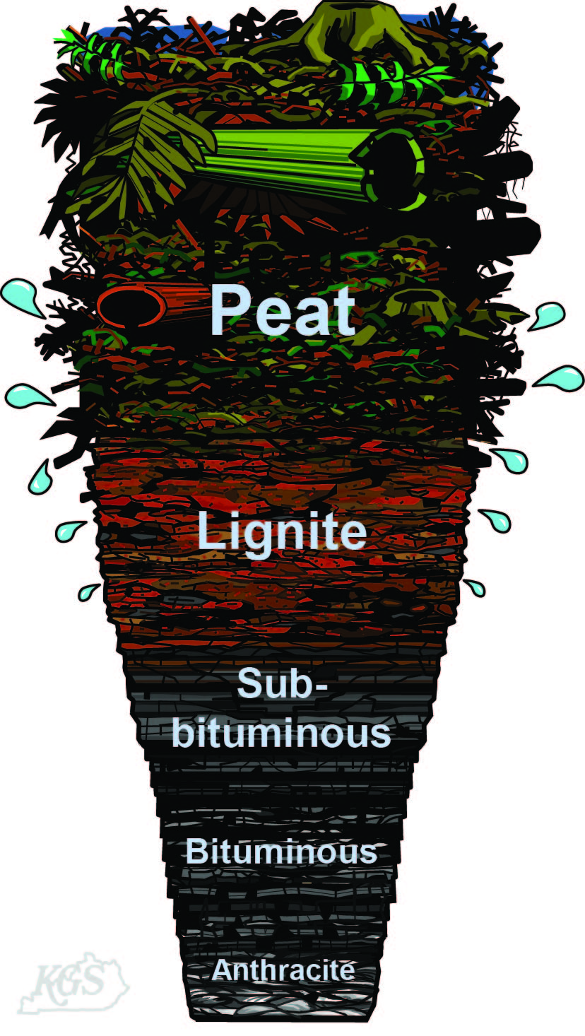
Coal is formed when peat is altered physically and chemically. This process is called "coalification." During coalification, peat undergoes several changes as a result of bacterial decay, compaction, heat, and time. Peat deposits are quite varied and contain everything from pristine plant parts (roots, bark, spores, etc.) to decayed plants, decay products, and even charcoal if the peat caught fire during accumulation. Peat deposits typically form in a waterlogged environment where plant debris accumulated; peat bogs and peat swamps are examples. In such an environment, the accumulation of plant debris exceeds the rate of bacterial decay of the debris. The bacterial decay rate is reduced because the available oxygen in organic-rich water is completely used up by the decaying process. Anaerobic (without oxygen) decay is much slower than aerobic decay.
For the peat to become coal, it must be buried by sediment. Burial compacts the peat and, consequently, much water is squeezed out during the first stages of burial. Continued burial and the addition of heat and time cause the complex hydrocarbon compounds in the peat to break down and alter in a variety of ways. The gaseous alteration products (methane is one) are typically expelled from the deposit, and the deposit becomes more and more carbon-rich as the other elements disperse. The stages of this trend proceed from plant debris through peat, lignite, sub-bituminous coal, bituminous coal, anthracite coal, to graphite (a pure carbon mineral).
Because of the amount of squeezing and water loss that accompanies the compaction of peat after burial, it is estimated that it took 10 vertical feet of original peat material to produce 1 vertical foot of bituminous coal in eastern and western Kentucky. The peat to coal ratio is variable and dependent on the original type of peat the coal came from and the rank of the coal.

The kinds of coal, in increasing order of alteration, are lignite (brown coal--immature), sub-bituminous, bituminous, and anthracite (mature). Coal starts off as peat. After a considerable amount of time, heat, and burial pressure, it is metamorphosed from peat to lignite. Lignite is considered to be "immature" coal at this stage of development because it is still somewhat light in color and it remains soft. As time passes, lignite increases in maturity by becoming darker and harder and is then classified as sub-bituminous coal. As this process of burial and alteration continues, more chemical and physical changes occur and a the coal is classified as bituminous. At this point the coal is dark and hard. Anthracite is the last of the classifications, and this terminology is used when the coal has reached ultimate maturation. Anthracite coal is very hard and shiny.
The degree of alteration (or metamorphism) that occurs as a coal matures from peat to anthracite is referred to as the "rank" of the coal. Low-rank coals include lignite and sub-bituminous coals. These coals have a lower energy content because they have a low carbon content. They are lighter (earthier) and have higher moisture levels. As time, heat, and burial pressure all increase, the rank does as well. High-rank coals, including bituminous and anthracite coals, contain more carbon than lower-rank coals which results in a much higher energy content. They have a more vitreous (shiny) appearance and lower moisture content then lower-rank coals.


High Resolution, 2.08 mb

Medium Resolution, 1.09 mb


High Resolution, 2.21 mb

Medium Resolution, 1.14 mb


High Resolution, 2.12 mb

Medium Resolution, 1.10 mb


High Resolution, 1.96 mb

Medium Resolution, 1.05 mb


High Resolution, 1.75 mb

Medium Resolution, 0.97 mb


High Resolution, 1.49 mb

Medium Resolution, 0.96 mb


Low Resolution 0.9 mb

High Resolution 2.1mb


UKY


Tuesday, April 23, 2013

Software Desain Penambangan Batubara

Minescape 4.118
Ready for Windows 8 x64

please contact 081343990492

Tuesday, January 15, 2013

So you want to be a mining engineer?


Australia is a major supplier of many natural resources, including coal, copper, bauxite, and gold. With the strong demand for Australian minerals continues to fuel mining activity in Australia, mining engineers are highly sought after and very well paid. Richard Dale manager of Robert Walters mining and engineering recruitment division outlines how you can become a mining engineer and what the role involves.
What does a mining engineer do?Mining engineers evaluate, plan, and oversee the building of mines. They also manage mining projects and monitor mines for their safety, environmental impact and efficiency. It involves all phases of mining operations: from exploration and discovery, through feasibility, development, production, processing and marketing, to final land restoration and rehabilitation.
What skills do I need in order to become a mining engineer?
To be a mining engineer you need an interest in natural resources and science, an understanding of the effects of mining on their surrounding environments, technical knowledge, problem  solving, communication and management skills.
Mining engineers should be prepared to work in outdoor conditions, at times remote from major cities.  You will be working with outdoor and underground elements, which can be physically demanding. Being in good shape will decrease the stress that is put on your body by working in all types of weather conditions.
Which qualifications do I need in order to become a mining engineer?
To become a qualified mining engineer a Bachelor of Engineering can be undertaken at many major Australian universities. A straight major in mining engineering integrates theory and practical application and involves mathematics, basic, earth and engineering sciences. Minors are available in minerals process engineering and geo-mechanics. Internships and work experience is also highly sought after, as many skills can only be gained through practical activities.
What area of mining can I work in?
There are many areas you can then go onto specialising in, for example, economic evaluation, drill and blast, ventilation, or design work. You could also specialise in a particular type of mining, such as underground or open pit mining, gold or coal mining.
How much can I earn working as a mining engineer?
In Australia mining engineers can expect to earn anywhere between $90 – 180k, depending on experience, location and speciality. For further insight into engineering salaries and recruitment trends access Robert Walters quarterly Mining and Engineering market updates.

Friday, December 28, 2012

SURPAC

Gemcom Surpac™ is the world’s most popular geology and mine planning software, supporting open pit and underground operations and exploration projects in more than 120 countries. The software delivers efficiency and accuracy through ease-of-use, powerful 3D graphics and workflow automation that can be aligned to company-specific processes and data flows.

Surpac addresses all the requirements of geologists, surveyors, and mining engineers in the resource sector and is flexible enough to be suitable for every commodity, orebody and mining method. Its multilingual capabilities allow global companies to support a common solution across their operations.


SURPAC BENEFITS

  • Comprehensive tools include: drillhole data management, geological modelling, block modelling, geostatistics, mine design, mine planning, resource estimation, and more.
  • Increased efficiencies within teams result from better sharing of data, skills and project knowledge.
  • All tasks in Surpac can be automated and aligned to company-specific processes and data flows.
  • Software ease-of-use ensures staff develop an understanding of the system and of project data quickly.
  • Surpac is modular and easily customised.
  • Surpac reduces data duplication by connecting to relational databases and interfacing with common file formats from GIS, CAD and other systems.
  • Integrated production scheduling with Gemcom MineSched™.
  • Multilingual support: English, Chinese, Russian, Spanish and French.

GEOLOGICAL AND RESOURCE MODELLING

Geologists use Surpac to determine the physical characteristics of a deposit, even when the information available to them is limited. They achieve this by harnessing the system's powerful
3D graphics, geostatistics, and an integrated modelling environment.
Data Management
  • Employ sophisticated geological data management tools to store, manage and review drilling data.
  • Interface to any popular database product and work in real time while connected to that data.
  • View and output sections quickly and easily using drillholes and existing topographic or pre-modelled data.
Estimation and Modelling
  • Outstanding tools for sample compositing and geostatistics.
  • Variogram modelling includes variogram fans and dynamic lag adjustment to help identify the best variograms for data.
  • Estimation tools include an interface to GSLIB for both normal kriging and conditional simulation options.
  • Comprehensive 3D wireframing tools enable the development of a truly representative model of any orebody.
  • Block modelling tools cover an extensive range of functionality and are easy to use.
  • Validating a model and generating any level of report can be done quickly and efficiently.

MINE PLANNING

Surpac delivers all the tools engineers need to create designs and plans for open pit and underground operations.In the system's integrated mine engineering environment, you can create design that maximise ore recovery, while complying with project constraints such as cut-off grade, economic limits and ground stability.
  • Data from various sources can be viewed and incorporated into plans to support feasibility projects.
  • Different pieces of information can be viewed simultaneously to ensure designs are within the physical constraints of the mining area and to maximise the economic extraction of a resource.
  • Data can be used directly from other software package formats with Surpac’s sophisticated Data Plug-ins.
  • Interact with all mine design data: drillholes; existing orebody and surface models; optimised pit shells; block and grid models, coloured by grade distribution; stope designs, and many more.

MINE PRODUCTION

Surpac provides applications for mining engineers, geologists and mine surveyors that ensure clear plans, effective communication and consistent data utilisation. The software manages drillhole, blasting and survey information, while linking to other databases used at mining operations.
Mine Survey and Ore Control
  • Calculate and validate volumes quickly.
  • Compare kriged models against raw drillhole data to optimise reserve extraction.
  • Produce high quality to-scale maps of any relevant project information.
  • Road and pit design tools are geared towards surveying setout, ensuring the necessary details required by earth movers are marked out accurately.
  • Integrated resource models, pit designs and survey data results in up-to-date ore markouts and dig plans with grade and tonnage reports.
Automated Workflows
  • Highlight end-of-month reconciliations and reporting problems through the simple automation of comparison reports using Surpac’s macro tools.
  • Automate repetitive grade control and plotting tasks using macro functionality, customisable to company-specific processes and data flows.
  • Develop new functions using the scripting language embedded within Surpac and assign routines to customised menu bars to better manage workflows.
Surpac Video

Surpac Example design @Quary Mining

Minex

THE ONLY INTEGRATED, END-TO-END GEOLOGY AND MINE PLANNING SOLUTION FOR COAL AND OTHER STRATIFIED DEPOSITS

Gemcom Minex™ is the only integrated, end-to-end mining software specifically designed for coal and other stratified deposits such as lignite, phosphate, bauxite, iron ore, and platinum. Fully integrating all aspects of mining from exploration through rehabilitation, Minex ensures that your resources are evaluated accurately and mined efficiently, improving your productivity and profitability throughout the mining lifecycle. Developed in partnership with the mining industry, the software is employed by the world’s largest mining companies.

MINEX BENEFITS

  • Speed – Minex is designed to rapidly model large, deep and data-intense coal projects. Minex’s high-speed and efficient modelling technology offers significant time and cost savings over other mining packages.
  • Transparency – Visually confirm each stage of the modelling and design process to ensure full confidence in the final model, resources and reserves.
  • Connectivity – Reduce data duplication by easily connecting to corporate databases and common file and data storage formats, including GIS, CAD and other mine planning data.
  • Lower total cost of ownership – Integration of geology, optimisation, design, planning, scheduling, survey, rehabilitation and other functions enables faster, more accurate decisions.

GEOLOGY MODELLING AND DEPOSIT EVALUATION

Minex offers a comprehensive geological modelling and reserves package for coal and other stratified deposits, such as lignite, phosphate, zinc, bauxite, iron ore, and platinum.

MINEX GEOLOGY MODULES:

Minex Modeling
The planned stages of developing a quarry are viewed in 3D. By importing data representing the surrounding areas and local community the visual impact of the project can be assessed, including nominating the camera position and target to assess the visual impact from a specific

MODELLING


Efet Banda
Customer Video:
Using Minex for Coal ModellingEfet Banda, Geologist,
The Mineral Corporation Consultancy Ltd.
The key to accurate geological modelling is effective interpretation. Minex uses all available data (i.e. geophysics, qualities, lithology, washability, and structural) to correlate and interpret the deposit.
  • A user configurable borehole database, with ODBC connectivity to the world’s leading corporate drillhole databases
  • Effective and efficient data validation and auditing
  • Fast and accurate Multi-Seam, Multi-Variable Modelling builds entire models, including seam floor, thickness, quality and other surfaces in minutes
  • On-screen deposit correlation
  • Missing data interpolation to maximise your data value across the entire deposit
  • Non-vertical holes to represent horizons at real locations, not the vertical-linear distance from the collar
  • Seam splitting and merging, washouts and shallow hole modelling
  • Complex model operations to determine strip or economic ratios for open pits
  • Contouring, sectioning, 3D borehole, statistics and histogram displays to maximize resource presentation to managers, mining engineers or investors
  • Generate sections, plans and reports on modeled attributes (e.g. ash, thickness or depth).
  • Detailed resource reporting, including editable run-time mathematical operations
  • Resource reporting to meet JORC, SAMREC or other stock exchange requirements
Minex Faulting
Seam Cross Section showing Boreholes, Geophysics and Gridded Seams
Plan of JORC Measured, Indicated and Inferred Borehole Classes

FAULTING

Minex Faulting advances the modelling process for deposits with complex faults. Minex interprets the faulted data and models it in its un-faulted state, thus facilitating modelling, understanding and interpretation of the deposit. Minex then re-faults the model to its current faulted position. Minex accurately models complex inclined or curved faults in normal or reverse environments.
  • Define faults with dip and fault throw or displacement
  • Generate fault blocks between faults and/or the limits of the deposit.
  • Model boreholes crossing faults accurately in 3D, across multiple fault blocks
The planned stages of developing a quarry are viewed in 3D. By importing data representing the surrounding areas and local community the visual impact of the project can be assessed, including nominating the camera position and target to assess the visual impact from a specific

COAL WASHABILITY

The Minex Coal Washability module models your complete wash curve so that yield, ash and other analyses can be modeled across the entire deposit.
  • Store and analyse size and density data in the Coal Washability database
  • Load both incremental and cumulative samples
  • Composite data for modelling, plotting and reporting by;
    • Cumulative size
    • Specific wash densities
    • Product ash targets
    • Yields
  • Report primary, secondary and tertiary product grades and yields.
The Coal Washability module also allows modelling of the wash data, allowing you to:
  • Compute product grade grids for coal production requirements
  • Use these grids in resourse and reserves reports to simulate plant processes by area or schedule time
The planned stages of developing a quarry are viewed in 3D. By importing data representing the surrounding areas and local community the visual impact of the project can be assessed, including nominating the camera position and target to assess the visual impact from a specific

Thursday, December 27, 2012

Minescape 5


What’s New in MineScape 5

MineScape 5 is a significant advancement in the product user interface and workflow - which can lead to productivity and efficiency gains for a Mining enterprise. Some of the exciting new features include:
  • Easy-to-Use, Graphical User Interface
  • Significantly improved graphics performance
  • Dual monitor support
  • Tear off the graphics window to a second monitor
  • Customizable toolbars
  • Easier to use, WYSIWYG plotting setup, batch plotting and image support
  • Project accessibility improvements
  • Redesigned Explorer with windows style searching and sorting
  • New table editor with group by area function
  • Open Cut Planning improvements
  • Dragline improvements
  • Plug-in architecture with an API provides integration opportunities to in-house and other applications
Click here to view more details about what’s new in MineScape 5.
Click here to view a Question and Answer document about MineScape 5.


MineScape Mine Planning and Design Software

Specifically developed to meet the mining industry’s rigorous demands, MineScape is used at more than 100 Indonesian coal mines. MineScape is a suite of integrated solutions designed for open cut and underground mining operations. It delivers extensive geological modelling and mine design functionality – making it the leading mine planning solution in Indonesia. Incorporating many features, MineScape offers exceptional ease-of-use and learning through:
  • An intuitive, familiar working environment that follows the Microsoft Windows User Experience Guidelines and the latest Microsoft .NET technology.
  • True simultaneous multi-user access to all 3D data and models.
  • Fully functional 3D CAD system utilising the latest Microsoft Direct X technology.
  • Support for centrally located project data and software configuration, which facilitates data version control and streamlines system setup and data backup.
  • Data publishing, which provides multiple users and projects with a single visible source of the latest model, mining plans, etc.
  • Time saving tools such as ‘pull-down’ and ‘tear-off’ menus, customisable toolbars, drag and drop, design status information, and MineScape sessions, which saves the current design configuration for later recall.
  • Client-server architecture, which provides automation of geologic modelling and mine planning processes. Process monitoring and control functionality saves inputs and processes, which can be easily re-run later.
  • MineScape Explorer to browse projects and manipulate data.
  • Tighter integration with Microsoft Office products.
All MineScape plug-ins are fully integrated with intuitive user interfaces, operating from a single database. Each plug-in performs a specific range of data processing and mine planning functions; these plug-ins are described in the following sections. 

MineScape Products Feature


Core MineScape

Core MineScape is the base system that all MineScape products plug into. Core MineScape provides support for customisation of the system.
CoreMinescape screenshot

Core MineScape offers:
  • A fully functional three-dimensional CAD environment containing robust commands purpose-built for geologic modelling and mine design.
  • Comprehensive mining-oriented function library including:
    • - Surface manipulation
    • - Gridding
    • - Triangulation
    • - CAD design
    • - Table / spreadsheet
  • Standard and custom reporting.
  • Intuitive and powerful plotting capabilities.
  • Easy-to-use process control functions for error checking and process automation.
  • Supports third party file types that are commonly used in mining.
Core MineScape is mandatory for any MineScape purchase.

Block Model

MineScape Block Model provides a sophisticated working environment where geologic rules are defined for the local geology. The deposit model is built by progressively introducing geologic elements through loading of physical interpreted shapes or interpolation using material associations and/or zone, followed by a selection of algorithms. The model can be displayed at any time to validate the model construction process, and the complete model becomes the base for reserves and other mine planning work.
Block Model provides geologic modelling capabilities for stratigraphic and non-stratigraphic deposits. Cell sizes are user-defined and can be oriented to fit the deposit. Block Model provides sub-cell capabilities to accurately define contact surfaces within the block model. Sparse block models are also supported, which limit the number of cells created to the area of interest. Block Model offers universal and ordinary kriging, inverse distance and nearest neighbour interpolation techniques for evaluating geologic attributes into the block model structure.
Integration with Stratmodel allows grade interpolation to follow along the stratigraphic structure. Integration with Geological Database (GDB) provides for streamlined interpolation of geologic quality data. Calculated geologic attribute values are also supported with a powerful mathematical expression language (MXL).
Block Model Reserves offers extensive categorisation capabilities to determine quantities and qualities of the deposit. Reserve estimates can be reported using the standard reports or may be exported to an Excel spreadsheet for post-processing and reporting.
Block Model screenshot


Geological Database (GDB)

MineScape GDB is designed to store drill hole, blast hole and point data. The application can function equally well at a mine site or corporate office. Databases can be defined, maintained and accessed on any machine for which TCP/IP access is available.
MineScape GDB uses Oracle RDBMS, which enables any third-party product such as MS Excel to access the database by ODBC connection. An Oracle database is required; supported versions include 9i, 10g, and 11g.

Stratmodel

MineScape Stratmodel provides a sophisticated working environment where stratigraphic deposits are modelled to represent the local geology. The geological model is built using user-defined rules and becomes the base for reserves and other mine planning work.
Stratmodel also provides excellent fault handling and is capable of modelling vertical, normal and reverse faulting in deposits, as well as providing for quality modelling of stratigraphic deposits. For thick stratigraphic seams with varying grade, it is recommended to take advantage of the integration between Stratmodel and Block Model and the surface-following interpolation technique available.

Dragline

Dragline is a CAD-oriented dragline modelling product that enables engineers to quickly and efficiently define and test dragline excavation methods on real pit models. Dragline includes functions to simulate and measure a wide variety of material movement methods, including cast blasting and production dozing. These functions allow operations in the pit to be faithfully modelled.
Dragline is the best tool for computer-based dig optimisation, allowing engineers to test new excavation quickly against real data. Dragline draws topographic and stratigraphic surface information directly from MineScape models. These can be simple sketches in planes and/or sections approximating geology, or real geology as defined by both pit survey and drilling through Stratmodel.

Drill & Blast

MineScape Drill & Blast provides the blast design engineer with an interactive 3D CAD environment within which an optimum blast can be quickly laid out, and the holes projected to the surfaces. Hole layout reports can be exported to GPS-equipped drill rigs. Drill & Blast is integrated with MineScape’s other plug-ins such as Stratmodel, which allows direct access to the geologic model when designing the blast. Drill & Blast uses the concept of area zones, which are created through polygons in CAD; zones in the vertical would be identified through integration with the stratigraphic model.

Roads

MineScape Roads provides an easy to use solution for designing mine haul roads and ramps. Even with limited experience, complex designs can be produced easily, enabling staff to quickly become more productive.
MineScape Roads enables you to design a road along any surface, with a menu-driven interface that guides the user through the road design process and provides design status feedback. Cuts and fills are generated as required whilst maintaining grade and curve specifications. Cross-sections and volumes are generated to allow the optimisation of road placement and estimation of construction costs. Maps and plans suitable for plotting are created during the design process and, with MineScape animation capabilities, the user can simulate driving down the completed road design.
Roads screenshot


Open Cut

Open Cut provides powerful tools to rapidly create and explore design options for open cut planning. Long term planning tools, such as strategic and feasibility studies, are complemented by tools for short term design objectives in terrace or strip mining situations for both dragline and truck & shovel mines.
Ultimate pit and ramp design is provided. User-defined pit geometries may be incorporated into the pit block construction using either polygon or line string design options to produce accurate blocks for the mine schedule. The Open Cut Wizard guides the user through the process and maintains multiple design scenarios for the user.
Open Cut screenshot


Survey

MineScape Survey enables the user to generate survey instructions automatically from mine plans and input survey results from a field recorder or field book directly into the MineScape database. Survey can be used to generate production reports and plans, and use the database information for further short-term planning rehabilitation and reconciliation.
Survey controls reduction management and the use of field survey data. The full range of surveyors’ reduction transformation and adjustment requirements are supported.

Schedule

MineScape Schedule provides both an interactive and automated approach to mine scheduling to support short-, medium- and long-term planning. User-defined shift schedules, machines and real date calendars are supported. User-defined forms provide the user with the status of machine production, ore qualities, target and inventories for a defined time period.

Underground Planning

MineScape Underground Planning speeds the repetitive and time-consuming CAD processes that create underground designs. By specifying design parameters through tables and templates, accurate designs are rapidly developed. Using standard MineScape tools to create a totally integrated system can further enhance these underground designs.

Geostatistic

MineScape Geostatistics provides a comprehensive tool for determining classical statistics, developing variograms and defining a Krige interpolation for quality modelling in stratigraphic deposits.

Ring Drill Design

MineScape Ring Drill Design provides an interactive 3D CAD environment from which to perform underground ring drill mine design and blasting. The user can design multiple drill rig positions inside or outside the ore body. Hole layout and projections can be controlled by domains and standoff from the domains. Hole charging and calculation of consumables and blast volumes are built into the system.